Datum
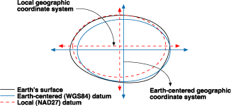
it defines the relationship between a local and a global three dimensional coordinate system of the same type, and it is defined as a re-position of a reference ellipsoid to be more accurate in representing a specific area . it also called local datum or national datum or just a datum.
Because an ellipsoid may be a best fit globally and the difference between the geoid and ellipsoid (n) be very minimum (globally) but not necessary for a specific area (country for example) so that a datum is created.
As every country wish to have an ellipsoid that is much accurate and close to the real surface of its land, some modifications may be applied to the previously best fitting global ellipsoid (correction for the ellipsoid parameters: a, b or e and f) or global reference system.
 |
| Photo source |
And that by taking a point and consider it as a datum centre point (datum origin point, it’s fixed and all other points are calculated from it), by assuming that this specific point is where the global ellipsoid conform with the geoied, and that will create a non geocentring ellipsoid. Like in Sudan we have Adindan local datum that has been gained by modifying the Clarcke 1880 ellipsoid, also Ain Elabd in Saudi Arabia, the Old Egyptian Datum 1907 obtained from Helmert 1906, NAD 27 (the horizontal datum of USA) from Clarcke 1866 and so on.
there are two types of datum:
1. Horizontal datum:
It’s used to describe and located points on the earth surface as longitude and latitude or other coordinate system.
2. Vertical datum:
Describe elevations or underwater depths.
 |
| Photo source |
As datums are non-geocentring, each point has different coordinate depending on which datum or reference system is used and transformations between one datum to another or from a datum to a global reference system must be applied
References:
1.GNSS – Global Navigation Satellite Systems, Bernhard Hofmann and others, 2007.
2.Introduction to GPS, Dawod Gomma, 2010.
3.http://desktop.arcgis.com/en/arcmap/10.3/guide-books/map-projections/datums.htm


Comments
Post a Comment