World Geodetic System 1984 (WGS 84)

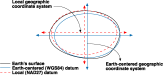
WGS 84 is developed by the U.S. Department of Defence, it’s the standard for use in cartography, geodesy, navigation and it’s the most known terrestrial reference system because it’s the reference system for the Global Positioning System (GPS) and that’s the main reason of the high acceptance of the WGS 84 as a primly reference system. Also the U.S. DoD uses it as the standard definition for global reference system for geospatial information. It’s Earth fixed, Earth centred (EFEC) Terrestrial Reference System or a Geocentred datum, based on a set of consistent constant and parameters that describe the Earth’s shape, size, gravity and geomagnetic fields. It’s a global coverage three dimensional Cartesian coordinate system (X,Y,Z), and it’s compatible with the International Terrestrial Reference System (ITRS) also to some extend it can be considered identical to the ITRF. The responsible organization for establishing and maintenance is the National Geospatial-Intelligence Agency (NGI...