International Terrestrial Reference Frame (ITRF)
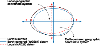
Coordinates system are baaed on assumption that the vertical axes coincide with the rotation axe of the earth, that is derived from another assumption that says the rotation axe of the earth is fixed. Although many scientists proved that this assumption is invalid, it still acceptable for some Geodetic application with resolution of 1 cm or more.
The rotation axe actually moves slightly resulting in very small changes on measurements, which taking them into account when high accuracy is need specially in applications that require accuracy of milometer or less such as detecting and measuring curst movement.
Also the over all shape of Earth change continuously so when the earth’s curst is measured it most be referred .
For that the International Terrestrial Reference Frame (ITRF) was developed. And an international organization called: International Earth Rotation and Reference Systems service (IERS), which was created in 1988, measure the rotation axe of the earth every three years to establish and maintain the ITRF, so there is a ITRF according to a specific epoch, as example: ITRF 1990, 1LITRF 1995 and so on. It provides a set of point coordinates located on the earth surface.
The rotation axe actually moves slightly resulting in very small changes on measurements, which taking them into account when high accuracy is need specially in applications that require accuracy of milometer or less such as detecting and measuring curst movement.
Also the over all shape of Earth change continuously so when the earth’s curst is measured it most be referred .
 |
| Photo source |
For that the International Terrestrial Reference Frame (ITRF) was developed. And an international organization called: International Earth Rotation and Reference Systems service (IERS), which was created in 1988, measure the rotation axe of the earth every three years to establish and maintain the ITRF, so there is a ITRF according to a specific epoch, as example: ITRF 1990, 1LITRF 1995 and so on. It provides a set of point coordinates located on the earth surface.
References:
1. http://desktop.arcgis.com/en/arcmap/10.3/guide-books/map-projections/datums.htm2. http://itrf.ensg.ign.fr/general.php

Comments
Post a Comment