Application of Thermal Remote Sensing in Fish Harvesting
Introduction:
Using satellites in fish harvesting is due to the great advantages they provide such as the wide range capture of see surface “large coverage”, temporal resolution and data are independent from weather. So that remote sensing has real impact on uncovering the relationship between fish distribution and surrounding environment.
The main objective of using remote sensing is to reduce search time and increase catch rate.
There are two methods to apply remote sensing data:
Indirect Method: measuring oceanographic and environmental factors that correlate with fish habitat, such as ocean colour, sea surface temperature (SST), wind stress, current data, and other environmental characteristic that affect fish habitat Also, known the fact that fish correlate with nutrient-rich waters.
Direct method: by spotting fish appearance.
Measuring the environmental factors is much easier than spotting the appearance of a fish. And the main source for fisheries management is thermal infrared and ocean colour.
Using remote sensing data require a previous knowledge about fish life pattern and ocean circulation, Behaviour of a given species at various temperature, Catch rate at a specific area and Biological quality of the water.
There is a lot applications of remote sensing used in fisheries, but here we are talking about the application of thermal data.
Sea Surface Temperature SST:
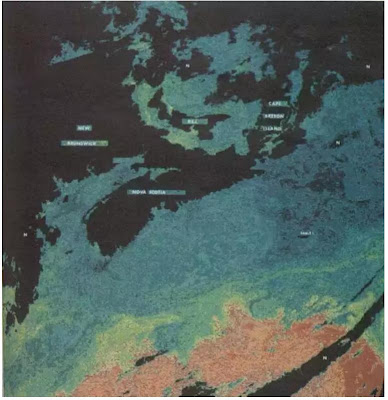
It is one of the indirect methods which is obtained directly from the remote sensing satellite measurement of the thermal band which is related to the object temperature. It has the longest historical and reliability.
As some fish species depend on the surrounding environment temperature, the SST can relate to their life cycle. Using this information some scantiest has identify the spawning grounds for some species. SST is used mainly for salmon and tuna.
SST is used to identify:
Temperature regime.
Upwelling zones and thermal fronts, which helps on charting the productive area.
Ocean circulation pattern (temperature pattern), which helps on understanding the transport of larvae and pelagic resources.
Despites the great advantages of thermal infrared, there are some problems with infrared data:
effect of cloud haze and moisture, which could be eliminate by comparing daily base photos due to the great temporal resolution of remote sensing satellites.
Also one of the problems is how relevant is the surface temperature measured by the satellite which can be validated by the measurement made by ships.
Measuring the infrared radiation provide more accurate thermal patterns which is needed for determining fish distribution and estimating stocks.
Sea Surface Temperature map.
Examples of satellites and sensors that provide Thermal Infrared data:
Landsat satellite, it is originally for land use but it also can be used in near shore and different studies.
GMS-1.
MODIS / T sensor.
TIRROS, NOAA, METEOSAT,GOES: accuracy of 0.5 to 2 c near real time.
Sensors like Seasat Multifrequency Microwave Radiometer (SMMR) and Advanced Very High Resolution Radiometer (AVHRR), has been used along time to measure the sea surface temperature and additionally the Thermal infrared band.
References:
Application of Satellite Remote Sensing to Fishery Studies in Japan, Ichiro Yamanaka, Far Seas Fisheries Research Laboratory, 1000 Orido, Shimizu 434, Japan.
Fisheries Applications, WSE instruments.
APPLICATION OF REMOTE SENSING TO MARINE FISHERIES: ALTERNATIVE APPROACHES, R. SUDARSHANANd others, Post Graduate Department uf Marine Biology, Karnatak University, Kodibag - 581 303, Karwar, India.
Use of thermal infrared remote sensing data for fisheries, environmental monitoring, oil and gas exploration, and ship routing. , Roffer M. A. And others.
APPLICATION OF REMOTE SENSING TO FISHERIES, Fisheries and Aquaculture Department.

Comments
Post a Comment