Posts

Application of Thermal Remote Sensing in Fish Harvesting
Image
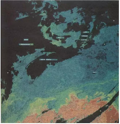
Introduction : Using satellites in fish harvesting is due to the great advantages they provide such as the wide range capture of see surface “large coverage”, temporal resolution and data are independent from weather. So that remote sensing has real impact on uncovering the relationship between fish distribution and surrounding environment. The main objective of using remote sensing is to reduce search time and increase catch rate. There are two methods to apply remote sensing data: Indirect Method: measuring oceanographic and environmental factors that correlate with fish habitat, such as ocean colour, sea surface temperature (SST), wind stress, current data, and other environmental characteristic that affect fish habitat Also, known the fact that fish correlate with nutrient-rich waters. Direct method: by spotting fish appearance.  Measuring the environmental factors is much easier than spotting the appearance of a fish. And the main source for fisheries management is thermal...

Hyperspectral Remote Sensing

Image
Introduction Hyper is a Greek word for "over", So hyperspectral term is used to distinguish the differences in the amount of spectral bands used in multispectral system. The principle concept of hyperspectral is similar to that used in the multispectral. Also both of them can apply across-track or along-track technique. Here will discuss the difference between them. Definition: Hyperspectral (also known as imaging spectrometer or imaging spectroscopy): it acquires images in about tens or hundred ( 64 - 254 ) or more contiguous bands and in a very narrow wavelength range ( 5 um to 10 um) which include (visible spectrum - near infrared - mid infrared - thermal infrared) regions. Examples: Hyperion system on EO1 satellite. Multispectral scanners can sense a few spectral bands compared to that of hyperspectral. And in a range of (0.3 - 14 um) wavelength including (ultra violate - visible spectrum - near infrared - mid infrared - thermal infrared) regions. Examples: Landsat MSS...

Application of Remote Sensing Technology in Bathymetric Survey

Image
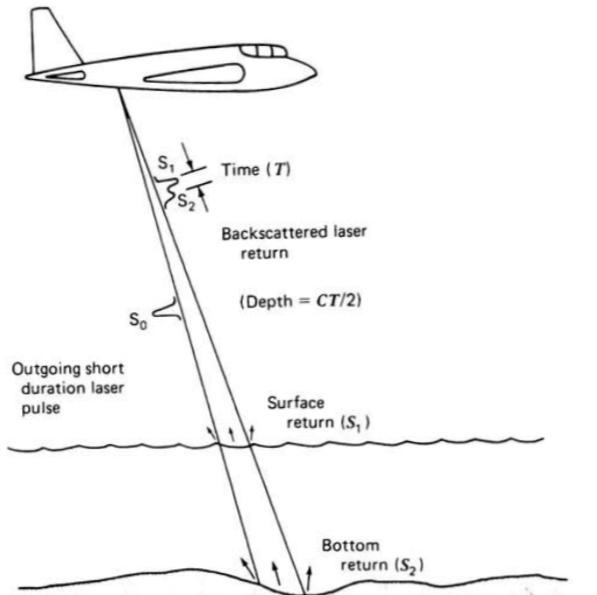
Introduction The determination of water depths is important to monitoring underwater topography, detection of moving sediments and to support navigation. To determine water depths, both active and passive remote sensing techniques are used. In fact; the active technique were used to validate passive technique results. 1. Active remote sensing technique: light detection and ranging “LIDAR”: One of LIDAR successful applications was measuring water depths. Using LIDAR started in the late 1970. The concept in LIDAR is the first reflection determine the water surface, followed by a second reflection, it’s weaker reflected pulse from the bottom. Then the depth can be computed from the differential travel time of the reflections. 2. Passive remote sensing technique: Using passive remote sensing technique in water is complicated due to the interaction with the atmosphere and  water. The combined effect of scattering and absorption of dissolved and  suspended material will limit the ...

Image Measurements and Refinements

Image
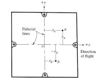
Introduction : The solution for most photogrammetric problems involves some photographic measurements. Sometimes the measurement is just the length of lines between imaged points or by row and column method to define the pixel location, and if the dimension of the pixel is known then this method can b. Converted into a linear coordinate this will create a left handed coordinate system which may cause some calculation problems. but the most common system is the rectangular coordinate, and it used directly in many photogrammetric equations. Image measurement can be done on a positive photo printed in a paper, glass, film or it can be manipulated digitally on a computer. It also can be made on negative photos but it is better to preserve the negative in case more positive may be printed because it may deface the negative. Also sometimes scanned negative into a digital from to prevent any additional cost for making positive images. Some errors occur during the process of image measurement...